Wednesday, September 20, 2006
SMEAR-asema ja Korvatunturi - SMEAR-measurements under Santa Claus mountain
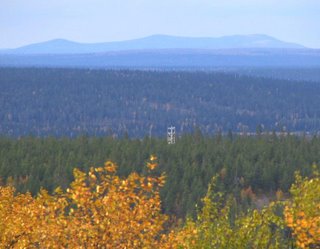
 Värriön tutkimusaseman SMEAR-mittausten nimeksi kaavailtiin alunperin (1991) jotakin Korvatunturiin ja Joulupukkiin liittyvää, esimerkiksi Joulupukin metsän mittausasema tms. Ajatushan ei ollut hullumpi, sillä Joulupukin maa on juuri SMEAR- asemasta pohjoiseen. Kuulakkaalla ilmalla jylhiä kolmihuippuisia tuntureita näkyy horisontin silhuetissa kaksikin. Niistä etäisempi, Venäjän puoleinen Juuoiva on vasemmassa kuvassa säähavaintotornin takana.
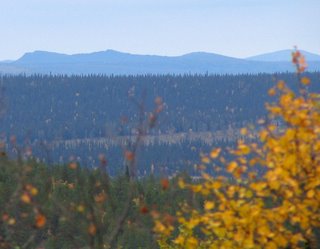
Hieman lähempänä, linnuntietä 38 kilometrin päässä näkyvä Korvatunturi on oikean puoleisessa kuvassa. Korvatunturin kolmihuipun oikealla puolella näkyy vielä neljäskin huippu. Se kuuluun Venäjän puolen Joutsenpäihin. Kuvaussuunta näissä poikkeuksellisen kirkkaan sään kuvissa on Rakitsan huipulta Kotovaaran männikön yli pohjoiseen.
 When the name for the SMEAR-station of Varrio was originally (1991) under consideration, the first suggestion included Korvatunturi fell and Santa Claus, into something like "Santa Claus forest ecological station". This is no wonder as the Santa Claus land is in the horizon just behind the station. Occasionally, when exceptionally clear weather and clean near atmosphere prevail it is possible to see silhouettes of two mountains as three-peaked fells. In the upper photo to the left the remote Juuoiva fell is seen behind the SMEAR climate tower. It is one the Russian border mountains.
In the lower photo to the right we can see the nearer Korvatunturi fell. The direct distance to from Varrio Research Station to Korvatunturi is 38 km. The border between Finland and Russia goes through the middle peak. Far in the right we can still se a fourth peak. It is on the Russian side, belonging to the distant Joutsenpaat -fells.
The photographing direction in these exceptionally clear weather photos was north of Rakitsa hill.